The geographical landscape of St Helena Island
Between 370 – 290 million years ago, the area around what is now Brisbane was covered by deep oceans and marine sediments were deposited in the area. From 250 to 150 million years ago volcanoes erupted around this area. The land was above sea-level but the area was covered by rivers and sandstone, and shale and coal were deposited from these into rivers and swamps. These subsequently formed a variety of rock types including sandstone, shale, coal, siltstone, mudstone, and conglomerate. Active volcanoes like Mt Warning in northern New South Wales were still shaping the landscape 23 million years ago and erosion continued to shape mountains and carve rivers and creek beds in the landscape in which to deposit sediments. (1)
Moreton Bay was shaped by the sand eroding from Mt Warning. Sand was carried from the eroding mountains to the sea via rivers and was then carried north by the ocean currents. Around 400,000 years ago, rocky outcrops at Cape Moreton and Point Lookout trapped these shifting sands, which gradually began to build up to form Moreton Island and Stradbroke Island on the outer side of Moreton Bay. (1)
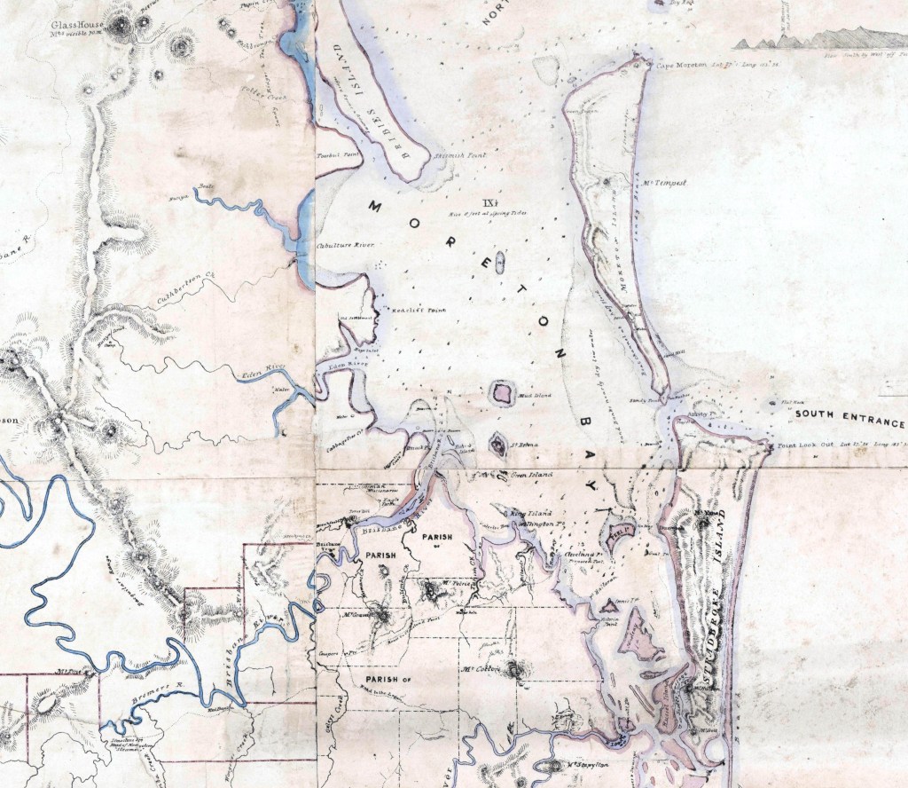
Climactic changes were also to play a part in shaping Moreton Bay as they were having great effect on sea levels. 200,000 years ago, the sea level was 50m lower than today and it reached its lowest point during an Ice Age approximately 155,000 years ago – 150 meters below todays level. Fluctuating levels over the past 120,000 years have seen Moreton Bay completely dry 4 times. The last Ice Age ended 19,000 years ago, when sea levels began to gradually rise, causing water to inundate what was then the floodplains of the Brisbane River. The current shape of Moreton Bay was formed roughly 6000 years ago as the rising sea level stabilised. At this point, the distance from Wynnum to the island would have been approx. 6 or 7 km. (1)
Government Surveyor Rawnsley’s 1865 report on the suitability of the island for a Quarantine Station, stated that the island:
- had 180 acres of good dark red (volcanic) soils, being covered with scrub and tall kangaroo grass.
- Elevation was 70 feet above sea level, gradually falling off at the south west, with sand flats to the north-west, west and south
- The rock on the island was fragile, being formed entirely of a conglomerate of shell fragments cemented together by lime and iron deposits. The rock is known as ‘Cay sandstone’, or locally as ‘beachrock.’ (2)
‘Beachrock’ or Cay sandstone
St Helena’s beachrock, or cay sandstone, was one of the main sources of stone used in the building of the Quarantine Station and the gaol on St Helena Island. ‘Beachrock’ is a conglomerate or sedimentary rock made up of pebbles, shell, coral and sand held together by calcite, clay or iron oxide. Quarrying for beachrock began in 1867 on the south-western foreshore, but gradually moved inland over time. Gangs of prisoners worked with a pick axe to extract a block of stone, which was soft when under the ground and which hardened on being brought to the surface and exposed to the air. Prisoners then ‘squared down’ or ‘dressed’ the stone with wood axes to large blocks which were carted by a horse and dray or trolley to the construction site. The enormous amount of stone quarried in the early years was used to erect nearly half the prison structures. (3)

Clay quarry and brickmaking
A clay quarry was established towards the northern end of the island, north of the dairy cattle yards. Early experiments in making bricks were initially unsuccessful, but by 1867, bricks capable of withstanding heat were successfully made by mixing the island’s red and white clays together. A kiln of 15,000 bricks was successfully burnt in 1868 and 64,000 in 1874. Island bricks were used to build bakery ovens, in the kitchen cooking areas and the lime kiln, amongst other sites. Bricks were also imported from the mainland to supplement the needs of the prison. (3)
Lime for cement
The production of lime for use as cement began in 1864 with the arrival of the Crompton family. The family had attempted to be part of a collective establishing cotton plantation in Pimpama, which failed, prompting the entire family to live on St Helena Island. Here they collected coral and shells which were stacked in large piles with firewood and then burned on site, the ash being bagged and transported to Mr. James Campbell in Brisbane as lime for cement and mortar. (3)

Construction of prison buildings also required cement, so a lime kiln was built in 1869 on the southern coastline. Prisoners collected coral from the intertidal flats at low tide and layered alternately with wood in the kiln’s funnel. This was then lit and burnt slowly over weeks, being continuously topped up. The extended walls at the front of the lime kiln funnelled the sea breezes into the funnel opening to fan the flames. The resulting lime/ask mixture would be shovelled by prisoners out of the small opening at the base of the funnel and place it into bags, and then used on the island or exported to Brisbane. (3)

Following the closure of the prison in QCL commenced coral extraction in Moreton Bay in 1937. In 1956, a 50-year exclusive licence was granted by the Queensland Government for the extraction of coral from the shallow shelf and off-shore areas of Mud Island (see Figure 1). Following this, a 25-year licence was granted in 1966 for the whole of the shelf surrounding St Helena and Green Islands and in 1989, an exclusive licence was grated to QCL to take dead coral limestone from areas near St Helena and Green Island. Community, environmental and political pressure to cease the extraction of dead coral limestone from Moreton Bay near Brisbane was a major factor contributing to the closure of Queensland Cement Limited’s Darra cement plant in 1998. (4)
Blog posts: Lime burning (Click on the links below)
The St Helena Island Community – connecting today’s community to a prison island of the past
An Abundance of Oysters and a Load of Lime
Moreton Bay Marine Park
Stretching from Caloundra to South Stradbroke Island and encompassing St Helena Island, Moreton Bay Marine Park is a diverse, valuable and important waterway on Queensland’s coast. The area around St Helena Island has been zoned a Marine National Park (green) zone which is an area of high conservation value. Boating, snorkelling and sailing are allowed, but no fishing, collecting or extracting of wildlife is permitted. (5)
Marine ecosystems and wildlife
Zoning as a Marine park protects a variety of ecosystems, including offshore coral reefs, seagrass meadows, rocky shores, sandy beaches and river estuaries. These in turn provide crucial habitat for a wide variety of species, including more than 1000 fish species, six marine turtle species (Green, Loggerhead, Hawksbill, Olive Ridley, Leatherback and Flatback), as well as the dugong Dugong dugon an important resident in the seagrass beds around St Helena Island. Larger species such as the threatened Grey nurse shark Charias taurus and the Humpback whale Megaptera novaeangliae also enjoy the deep waters of the bay. (5)

St Helena Island National Park
St Helena Island National Park was gazetted in 1979 primarily for its historic and cultural values. The site is listed as being of national significance on the State Heritage Register. St Helena Island was the first national park in Queensland to conserve, manage and present an extensive, complex non-Aboriginal historical place to the public. While the park was gazetted primarily for its cultural heritage values, the island has significant natural values that require ongoing proactive management. (6)
Wetland vegetation
St Helena National Park forms part of the Moreton Bay Aggregation wetlands, which are listed as nationally significant on the Australian Wetlands Database. The Moreton Bay Aggregate wetlands provide a diverse and rich suite of wetland habitats which are particularly significant as habitat for migratory waders. The northern end of St Helena Island comprises extensive estuarine mangrove wetlands that flood in higher tides, dominated by the Grey mangrove Avicennia marina, as well as saltmarsh communities. (6) (7)

Migratory shorebirds
The Ramsar List is the world’s largest network of protected areas, comprising of over 2,500 Ramsar Sites and 2.5 million square kilometres across the world. St Helena Island is part of Queensland’s internationally significant Moreton Bay Ramsar site due to its populations of migratory and resident shorebirds, including the endangered little tern Sternula albifrons and other birds listed under international agreements. (6) (7)
| Scientific name | Common name | Nature Conservation Act 1992 status | Back on Track status |
| Sterna albifrons | little tern | Endangered | High |
| Scientific name | Common name | JAMBA | CAMBA |
| Ardea ibis | cattle egret | √ | √ |
| Ardea modesta | eastern great egret | √ | √ |
| Charadrius bicinctus | double-banded plover | ||
| Charadrius mongolus | lesser sand plover | √ | √ |
| Egretta sacra | eastern reef egret | √ | |
| Haliaeetus leucogaster | white-bellied sea eagle | √ | |
| Hydroprogne caspia | caspian tern | √ | |
| Merops ornatus | rainbow bee-eater | √ | |
| Pandion cristatus | eastern osprey | ||
| Pluvialis fulva | pacific golden plover | ||
| Sterna albifrons | little tern | √ | √ |
CAMBA: China–Australia Migratory Bird Agreement JAMBA: Japan–Australia Migratory Bird Agreement
Source: St Helena Island National Park Management Statement 2013, extended 2023.
Island Vegetation
Original forest and scrub
A littoral vine forest, a dry, coastal vine forest, was the original vegetation that grew over the elevated parts of St Helena Island. Comprising of a variety of trees, scrub, vines and ground covers, St Helena’s original forest was known to contain some important but under-valued species, including the Tulipwood or Harpullia pendula, a small to medium sized rainforest tree. Archibald Meston in 1889 recalls “I recollect being told that tulipwood, to the value of about £2000, was cut down and burned off on our island of St Helena before the nature of the wood was discovered.” (8)

From 1866, theisland was cleared of native vegetation to make way for the construction of the penal establishment structures and for agriculture and cropping. Much of the original forest timber was considered to be too soft for building purposes, but some was used for fencing and fires for cooking. However, much of it was burnt on a large scale on the island. Today, areas of St Helena that are within the national park are comprised of almost entirely ‘non-remnant’ vegetation, however a recovering littoral vine forest community is becoming re-established along the east and south-east escarpments. (6)

Image: Montagu of Beaulieu, Henry John Douglas-Scott-Montagu. (1853). St. Helena, Moreton Bay, 20th July, 1853 from httpnla.gov.aunla.obj-134723485
Blog posts: Original forest (Click on the links below)
Introduced vegetation
The St Helena Penal Establishment aimed to become self-sufficient, establishing livestock and crops to sustain the prison population and for export. Sugar cane Saccharum officinarum wasgrown extensively on the southern flats of the island from 1868 until 1889, along with maize and lucerne for fodder. Vegetables such as potatoes, pumpkins, sweet potatoes and cabbages were planted on the elevated portions of the island, near the prison stockade. Fruit trees were planted extensively, including around 7 acres of mulberry trees, planted in 1875 for a sericulture industry. (3)
Distinctive trees today
Many species introduced during the prison era remain on St Helena Island today. The Superintendent’s formal garden contains many large such as Bunya, Norfolk Island and Hoop pines, Tuckeroo, White cedar, Black bean trees and Poinciana trees. The functional area of the Superintendent’s garden contains fruit trees including mango, custard apple and date palms. A giant bamboo stand remains today to the south-east of the dairy. (3)

Blog posts: Superintendent’s garden (Click on the links below)
Bamboo and butter – sketching the Superintendent’s Garden
Bella Sombre
The Bella Sombre plant Phytolacca dioica is actually more of a herb due to its herbaceous ancestors. It can grow up to 18 meters tall and have a huge umbrella shaped canopy, but its branches are spongy and easily broken due to being 80% water. The name ‘Bella Sombre’ means ‘Beautiful Shade’ in Spanish. (3)
Blog posts: Bella Sombre (Click on the links below)
When is a tree a herb? Behold the Bella Sombre.

Sisal hemp
“Agave sisalina’ plants, procured from the West Indies, were growing prolifically on the island for over 12 years before larger scale rope production commenced in the 1900’s. A ‘rapsador’ machine would extract the fibre from these plants to create rope. These plants can be seen fringing the elevated parts of the island. (3)
Olive Grove
An olive grove was planted on St Helena Island after 1886. Father William De Lange planted several olive trees Olea europaea on the island which were imported from the Middle East. The Chief Warder’s reports in the 1910’s indicated that gangs were involved in picking olives, extracting oil and bottling for use on island. In 1910, 151/2 gallons of olive oil was manufactured and in 1915 olives were sold for £1.19/-.
Blog posts: Olive grove (Click on the links below)
The good oil – St Helena olives

References:
- Hall, J. and Robins, R., A working model of Moreton Island Prehistory: MRAP stage 1. Queensland Archaeological Research 1: 85-94. (PDF) Hall, J. and Robins, R. 1984. A Working Model of Moreton Island Prehistory: MRAP Stage 1. Queensland Archaeological Research 1: 85-94.
- Colonial Secretary’s correspondence (various). Qld State Archives.
- Daly, B. ‘The St Helena Island Community www.sthelenacommunity.com.au
- Hogan, A. and Ritchie, S. (n.d.) A Managed Approach to Exiting Coral Dredging Operations in Moreton Bay, Qld Cement Limited Group. www.rag.org.au/mudis/qcl.htm
- Moreton Bay Marine Park User Guide, (n.d). Department of the Environment, Tourism, Science and Innovation. Moreton Bay Marine Park User Guide
- St Helena Island National Park Management Statement 2013 (extended 2023). Queensland Parks & Wildlife Service (QPWS), Department of Environment and Science.
- The Ramsar list, (n.d). RAMSAR – The convention on wetlands. https://www.ramsar.org/our-work/wetlands-international-importance/ramsar-list
- Meston, A. (1889). Forest Conservation. Brisbane Courier (Qld. : 1864 – 1933), Wednesday 11 September 1889, page 7.