First Nations culture
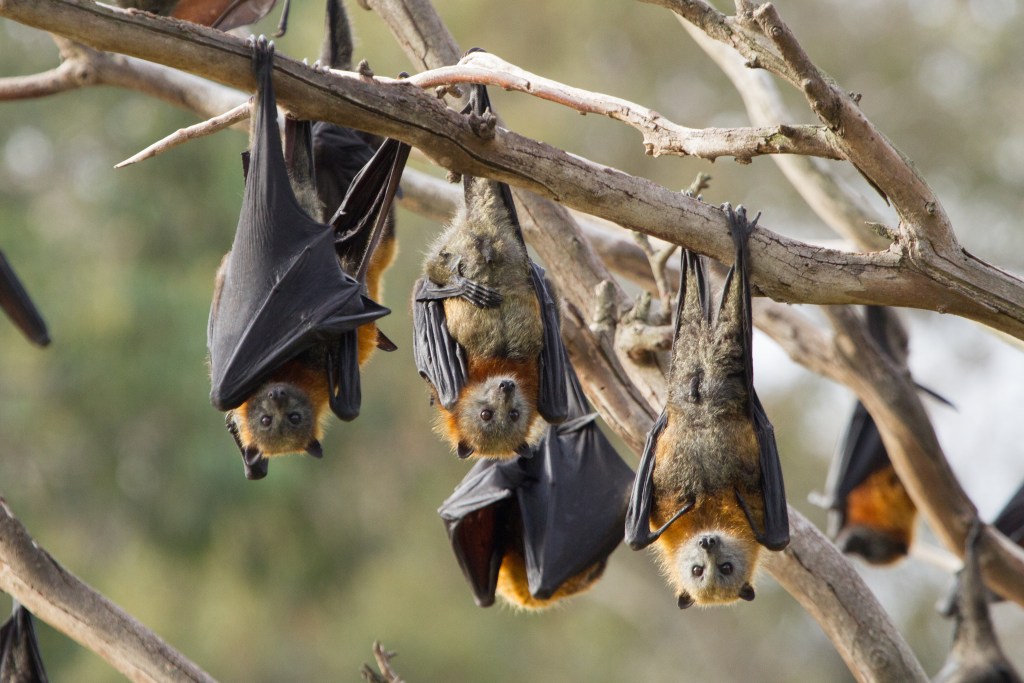
St Helena Island’s traditional name is No-gun or Noogoon, which means ‘home of the flying fox.’ The island is an important site for Aboriginal people from the Moreton Bay islands and the mainland, who utilised the resources on the island seasonally.
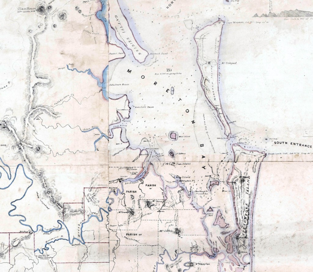
Research to date indicates that aboriginal inhabitation of the Moreton Bay area took place after the last sea level rise about 6000 years before present, when the land masses were similar to current conditions. The shallowing of the bay due to the build up of sand and mud flats off the mouth of the Brisbane River enhanced the potential for island hopping and would have decreased the risks of wind and high waves associated with a water crossing. At this point, the distance from Wynnum to the island would have been approx. 6 or 7 km and the river mouth to St Helena approx. 2 km. (1)
The island was not utilised as a permanent home for any particular group of people, but rather utilised seasonally throughout the year for its food resources. Tom Petrie writes of the Wynnum tribe canoeing across to the island for Flying fox and dugong hunting in the mid 1800’s. (2) J. Steele’s ‘Aboriginal Pathways of S.E. Qld records that ‘the territory of the Jandai-speaking people straddles Moreton Bay and includes many of the small islands within the Bay, from Macleay Island in the south to Mud Island in the north. The Coobenpil clan claimed most of this territory. The small islands were visited from time to time, but they had no permanent residents’ (3)
Today, Native Title established in July 2011 recognises the Quandamooka people as being the Traditional Custodians of the land and sea on and surrounding North Stradbroke Island, the southern part of Moreton Island, Bird Island, Goat Island, Peel Island and surrounding offshore areas. The combined determination area is about 54,472 hectares, with native title determined to exist over about 54,408 hectares of land and waters. This does not currently include St Helena Island. (4)
Wells
St Helena Island is known for its permanent water supply due to the presence of underground water tables. Surveyor Rawnsey collected a sample of water from ‘the Native wells’ in 1865. (5) This indicates that some wells had been constructed by local Aboriginal people to provide an ongoing accessible water supply.
Midden & Artefacts
A study from Gillian Alfredson on the St Helena Island midden shows evidence of over 2000 years of Aboriginal use, with the oldest estimated use being 2700 years ago. (1) Between 600 and 1350 years ago, a marked increase in shell density, the large majority (75%) including oyster, whelk and mussel, occurs through the midden. This is more consistent with a mainland midden, indicating a change in the pattern of use as women accessed the island, possibly due to the potential of ‘island hopping’ especially in the southern end of the bay. Another 34 different marine molluscs were also found in the midden.
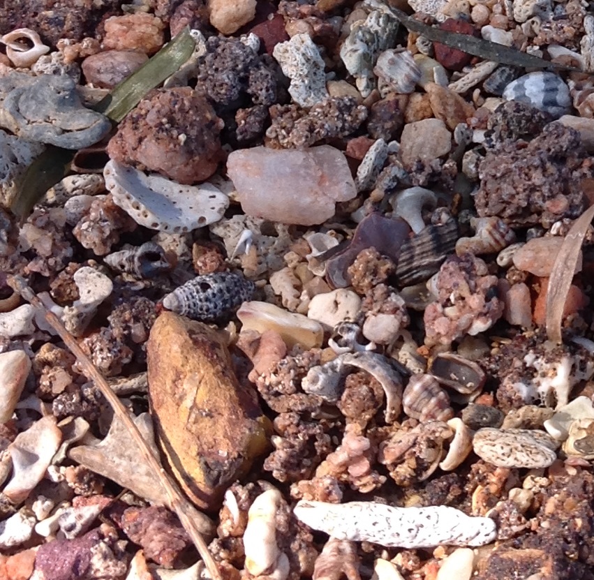
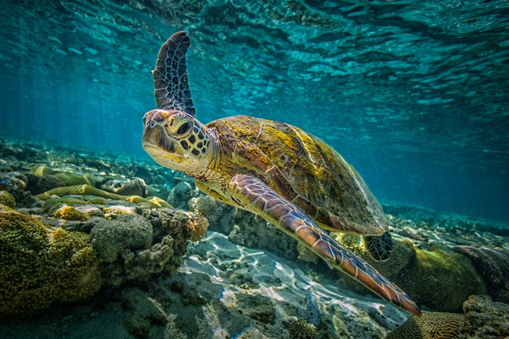
Within the midden, Fish and Flying Fox Pteropus poliocephalus, comprised most of the bone excavated from the midden, other vertebrates were dugong, lizard and possibly both marine and freshwater turtle. Fish identified included bream, tarwhine, mullet and whiting. It is the first time that eel-tailed catfish, weasel shark and stonefish have been reported from a Moreton Bay midden. Coral, mud crab and other crustacean fragments were also found – the presence of large amounts of coral and bone in the midden was considered unusual. Land snails were also identified and pips from the blueberry ash Eleaeocarpus reticulates, these being an excellent indicator that a lowland subtropical vine forest originally grew on the island. Fungi and fern spores found were also indicative of a damp environment. Small amounts of charcoal were also found in the midden. (1)
An Aboriginal scatter in the southern flats paddocks contains artefacts of tools such as stone flakes, cores and broken grindstones, sourced from the island. The predominant material used in artefacts were mudstone, silcrete, quartz, chert and a dark quartzite (1).
Flying fox
J.K.E. Fairholme, in his report to the Zoological Society of London in 1856, wrote ‘on the coast of Moreton Bay the natives live principally on fish, and the arrival of the flying foxes on St Helena was hailed by them as a change of diet. The flights only occur in the warmer months of the year … the flying foxes were caught as they slept during the day.’ (6) Tom Petrie, who migrated to Brisbane as a child with his family and grew up amongst the Aboriginal people of the area from the late 1840’s, remembers:

“St Helena was a great camping place for them (flying foxes) in those days, and the Aboriginals from Wynnum used to go across in their canoes to catch them there, watching for calm weather both to go and return. If the return was not delayed, they would bring back foxes cooked ready for their companions left behind, but they went prepared with fishing nets etc. as the wind might keep them there for some time.” (2)
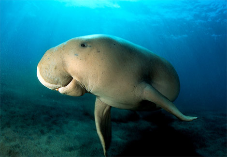
Dugong
Tom Petrie describes early Aboriginal canoes as ‘one-piece sewn bark sheet canoes, usually made from swamp mahogany trees.’ (2) Regarding Dugong (Dugong dugon) hunting, he recounts:
‘Then two blacks would get into a canoe and paddle quietly out, so as to get behind the dugong, other nine or ten would go with their large hand nets out into the water up to their necks, on the banks, and they would stand there all in a line, each holding the other’s net, as well as his own, so making a regular wall. Then, when the creatures came up again to blow again near this trap, the men in the canoe would hit the water with sticks and make a great noise, so frightening their prey towards the nets. When one got into the pocket of a net, the men would all help and hold on, till the creature rolled itself round and round, and so got drowned.’ Once captured, the dugong was rolled onto a fire, with fire on top and when half cooked the head and tail were cut off, the back opened and the carcass cut up. The meat was consumed by all in the tribe. (2)
Fish
Nets are commonly referred to in the early records of Moreton Bay. John Unaicke (who was on John Oxley’s 1823 expedition) wrote that the nets used for fishing ‘are made by the men from the bark of the kurrajong (Hibiscus heterophyllus).’ And Watkins talks of using the bark of the native cotton tree (Hibiscus tiliaceous), wattle bark and a vine, twisted together with gum to bind them. Tow-row nets were ‘heart shaped’ nets made with 2 branches forming the frame and handle and the fibre mesh strung between. Other fishing tools for sandflats, intertidal zones and mangrove areas included fish traps and spears. (7)
Legend of the construction of the Moreton Bay islands
‘The islands of Moreton Bay feature in a legend which tells of a bittern (a long-beaked bird) who caught a dugong in his net at Dumba on South Stradbroke Island. He decided to tease his friends who were looking forward to feasting on the dugong flesh, so he towed the dugong behind his canoe, and they all followed in theirs. He camped at Russel Island, at Coochie Mudlo, at Peel, Green and St Helena Islands, and each time he stopped his friends were disappointed, but at last the feast was held at Mud Island. The ‘old woman ghost of the island’ appeared. Knowing that she would try to capture all the freshly-cooked meat, they fled in their canoes. In a rage, the old woman hit the waves, causing the canoes to capsize and strewing the water with pieces of meat, each piece turned into a dugong’. This legend, which mentions the islands in their sequence from south to north, is an example of the way in which a legend could serve as a geography lesson.
(3) Steele, J. (1984) Aboriginal Pathways of S.E. Qld, University of Qld Press
Blog posts: Aboriginal culture and history (Click on links below to access stories)
1 night and 21,000 years on Stradbroke Island
‘Book of Past Scenes and My own experience Among Blacks In the Wild Bush of Australia’
What’s in a name? Napoleon and St Helena Island
European cultural heritage
St Helena Island National Park was gazetted in 1979 primarily for its historic and cultural values. The site is listed as being of national significance on the State Heritage Register. St Helena Island was the first national park in Queensland to conserve, manage and present an extensive, complex non-Aboriginal historical place to the public. (8)

Dugong hunting
Herds of dugongs were observed in their hundreds in the mid 1800’s in the Moreton Bay area. Dr. William Hobbs, Government Medical Officer for Moreton Bay partnered with T. Warry to begin manufacturing Dugong Oil on a large scale for medicinal benefits. One crucial site in the 1850’s was St Helena Island, where boiling down works were established on the southern end of the island. In 1861 and 1862, “under the superintendence of an experienced person formerly engaged in the seal trade in Newfoundland. Around this lovely island, for miles in every direction, are extensive submarine pastures of great luxuriance, affording a never-failing supply of long grass and upon which the herd of dugong feed and fatten like oxen upon the plains.” (9) Enormous amounts of dugong oil were produced and exported around Qld and overseas to England and Europe. However populations of dugong started to rapidly decline and dugong hunting on St Helena Island ceased in the 1860’s.
Lime Burning and the Crompton family
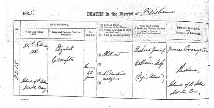
James Crompton and his wife Elizabeth (nee Greenough) emigrated from Lancashire, England to Moreton Bay in 1863 with their ten children. After their cotton cooperative venture in Pimpama failed, they moved onto St Helena Island in 1864 with a view of making money from the creation of lime. The family were involved in burning coral, oysters and other shells in large piles, scooping the ash into bags to transport to Brisbane for cement making businessman James Campbell, to be used as cement and mortar. (10) The family was on St Helena Island in 1865, evidenced by the death certificate of the family matriarch Elizabeth Crompton. (11) She died, aged 43, from phthisis on the Island of St Helena in Moreton Bay and was buried on the island on 24 February 1865, location unknown. By 1866, James Crompton and his family were recorded as living at Victoria Point and still involved in lime burning.
Blog posts: Lime burning and the Crompton family (Click on links below to access stories)
Immigration and the Quarantine Station
Large ships filled with new immigrants from Britain brought great hope to the new Moreton Bay colony. They also brought deadly diseases and many patients dead or dying on board. Many islands in Moreton Bay were requisitioned to receive and quarantine immigrants, allowing any sickness to be kept away from Brisbane. St Helena Island was used initially in 1852 as a burial site for people dying on board the ship ‘Maria Soames’ on its arrival in Moreton Bay. Research from The St Helena Island Community and Liam Baker reveal 12 known immigrant deaths on board ships quarantined near St Helena Island and 10 known burials on St Helena Island, including 1 man, 3 women and 6 children. (10) (12)
However, from 1862, immigrants from the ‘Chatsworth’ and the ‘Erin Go Bragh’ were landed on St Helena Island to provide the opportunity to clear people from the ships. There were, however no facilities for any people at all. Tents had been placed ashore for a small number of ill patients, but with nowhere to be housed the rest stayed ashore. A visit from ‘The Golden City’ in March 1866 changed that, as the Inquiry into the handling of their situation showcased an urgent need for some facilities. (10) Parliament moved fast, asking their Colonial Architect Charles Tiffen to design and create plans for a Quarantine Station on St Helena.
Prisoners were rowed ashore to build the Quarantine Station and by September 1866, one building was finished and another underway. Within 6 months the decision was reversed, as the decision was made for Dunwich to be the major site for Quarantine. A greater need had presented itself – lack of accommodated for prisoners in Brisbane Prison – and St Helena’s buildings were reused for the accommodation of prisoners.
Blog posts: Immigration and Quarantine Station (Click on links below to access stories)
New arrivals, new stories and old mysteries in 1852
New arrivals, new stories and old mysteries – 1862
New arrivals, new stories and old mysteries – 1862 was a busy year.
The Haunts of Brisbane: The tragic little burial ground Moreton Bay never knew it had… [PART I]
The Haunts of Brisbane: The tragic little burial ground Moreton Bay never knew it had [PART II]
St Helena Island Penal Establishment
Rowing across the waters of Moreton Bay, Queensland in 1866, prisoners contained aboard the hulk ‘Prosperpine’ were given the task of building the Quarantine Station and later Penal Settlement on St Helena Island. By December 1866, 18 prisoners were at work “at Government works” on the island of St Helena and were also being confined on the island. St Helena Penal Settlement was officially opened on the 20th May 1867. At this time, 45 prisoners were confined on the island, supervised by Superintendent John McDonald, 9 Military Guards from the 50th Queen’s Own regiment and 6 prison warders, many transferring from their water police roles on the prison hulk. (10)

St Helena grew to be a large, disciplined prison for male prisoners from all over Queensland. Folklore presents it as “The Hell hole of the Pacific”, but this generalised title obliterates the nuanced, complex and unique history of this fascinating site. Head to the website page St Helena Island Penal Establishment for specific insights and details of the management, regulations and people engaged in running this prison. St Helena Penal Establishment functioned as an important penal site in Brisbane for 65 years. During this time, it changed greatly over that time period, reflecting changes in society and attitudes towards punishment and reform.
Major changes occurred to the prison in 1921. A decision was made by the governor, to downgrade the prison to “be used more as a reformatory than a prison.” On the 13th September 1921, the prison warder staff was reduced from 45 to 16 warders. Prisoners were also halved in 1921, from 158 to 89, leaving the site (10) as a prison farm ‘for the imprisonment of prisoners serving sentences of 12 months and upwards.” The prison farm regulations were more lenient, and an ‘Honesty system’ was introduced by the last Acting Superintendent Patrick Roche. The prison finally closed in December 1932.

Blog posts: St Helena Penal Establishment (Click on links below to access stories)
The first escape from the first family
ONE DAY IN SEPTEMBER ON ST HELENA ISLAND – prisoners
ONE DAY IN SEPTEMBER ON ST HELENA ISLAND – Warders
References
- Alfredson G. (1984) An Archaelogical Investigation into Aboriginal Use of St Helena Island of Moreton Bay, University of Queensland, Brisbane.
- Petrie, Constance (1904) Tom Petrie’s Early Reminiscences of Early Queensland, Angus and Robertson Publishers
- Steele, J. (1984) Aboriginal Pathways of S.E. Qld, University of Qld Press
- Quandamooka People’s native title determinations North Stradbroke Island 4 July 2011. Published by the National Native Title Tribunal © Commonwealth of Australia, June 2011.
- Colonial Secretary’s correspondence (various). Qld State Archives.
- Fairholme, J.K.E, (1857) Observations on the Pteropus of Australia. Published in Annals And Magazine of Natural History, in 1857, in volume 19, pages 346-347
- Walters, Ian. Some observations on the material culture of Aboriginal Fishing in the Moreton Bay Area: Implications for Archaeology, Anthropology and Sociology Department, University of Queensland.
- St Helena Island National Park Management Statement 2013 (extended 2023). Queensland Parks & Wildlife Service (QPWS), Department of Environment and Science.
- Submarine Squatting In The New Colony of Queensland: A New Source of Health and Wealth. (1860, January 26). The Moreton Bay Courier (Brisbane, Qld. : 1846 – 1861), p. 2. Retrieved June 15, 2025, from http://nla.gov.au/nla.news-article372257
- Daly, B. (date) The St Helena Island Community
- Death certificate, Elizabeth Crompton. Sourced from Sandy Liddle.
- Liam Baker, ‘The Haunts of Brisbane’